What is GIS?
GIS stands for “geographic information system” and refers to computer mapping tools and resources. When digital information is geographically referenced it can be used to create map layers as well as to perform analyses and even model hypothetical situations (“what if?” scenarios). GIS has been used by the defense, natural resources, and planning communities for many years, and is now being used by many more sectors including transportation, marketing, utilities, emergency management, sales, and education, to name just a few.
GIS at NRPC
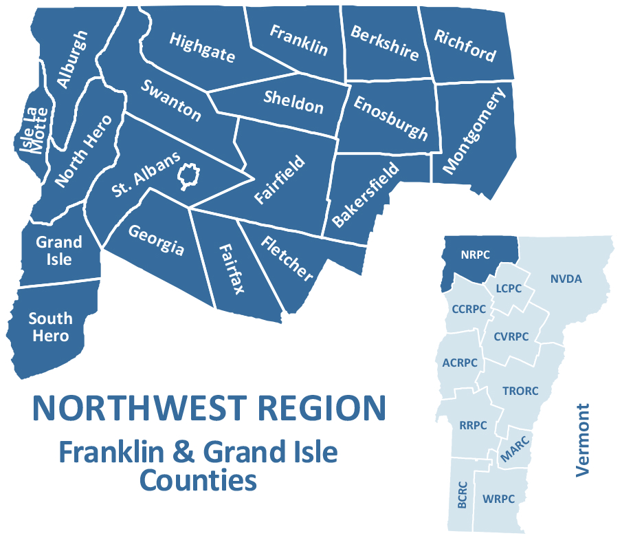
The Northwest Regional Planning Commission serves the counties of Franklin and Grand Isle. We provide GIS services to the northwest region of Vermont on projects that involve land use planning, transportation planning, emergency planning, and community development.
GIS Data and Online Mapping
If you are interested in finding GIS Data and information visit the State of Vermont’s Open Geodata Portal website. On this website you can find E911 data, roads, public/conserved lands, parcel boundaries, lidar, imagery and much more information.
The following links offer online mapping resources:
The maps shown below are for planning purposes only. These maps are provided for your convenience, however, it may not be the most current information. Most of the data used on these maps were from the State of Vermont’s Open Geodata Portal. If you are interested in finding GIS Data and information visit the State of Vermont’s Open Geodata Portal website.
Region Maps
Regional Plan Maps
The Northwest Regional Plan addresses the economic, social and environmental factors that influence and sustain growth and development in the region. The plan was prepared under the direction of the NRPC’s Board of Commissioners with significant input and guidance from residents, communities and partner organizations. For more information on the Northwest Regional Plan click here.
These are the current maps in the Northwest Regional Plan:
INTRODUCTION
MAP 1: Northwest Region Base Map
MAP 2: Housing and Transportation Costs
MAP 3: NRPC at Work
ECONOMIC REGION
MAP 1: Northern Vermont Economic Development District
MAP 2: Sheffield-Highgate Export Interface (SHEI)
SOCIAL REGION
MAP 1: Change in Elementary School Enrollment 2015-2022
MAP 2: Northwest Region Facilities
MAP 3: Northwest Region Trails
MAP 4: Median Sale Prices of Primary Residences (2023)
PHYSICAL REGION
MAP 1: Northwest Region Highways
MAP 2: Northwest Region Railroads
MAP 3: RCT Shuttle Routes
MAP 4: Transportation Facilities
MAP 5: Northwest Region Workers
MAP 6: Agricultural and Forestry Soils
MAP 7: Northwest Region Watersheds
MAP 8: Targeted Impaired Areas
MAP 9: Water Resources
MAP 10: Conserved Land
MAP 11: Wildlife Habitat
MAP 12: Current Land Use
MAP 13: Northwest Region Future Land Use Planning Areas
MAP 14: Northwest Region Centers and Village Areas
MAP 15: Northwest Region Center and Planned Growth Areas
MAP 16: River Corridors
MAP 17: Municipal Sewer and Water Systems
APPENDICES
MAP 1: Environmental Justice Focus Populations
Energy Plan Maps
Northwest Regional Planning Commission (NRPC) adopted the Regional Energy Plan on March 25, 2026. This plan supports the implementation of the Vermont Comprehensive Energy Plan (CEP) and the pursuit of Vermont’s energy and carbon-related goals. NRPC has a standing Regional Energy Committee composed of Regional Commissioners. The Committee works on projects related to implementing the Regional Energy Plan. NRPC is also involved in the review of proposed renewable electricity energy facilities as an automatic party to all Section 248 proceedings in Franklin and Grand Isle Counties. For more information on the Regional Energy Plan click here.
These are the current regional maps in the Northwest Regional Energy Plan:
Energy Burden
Existing Generation Facilities
Hydro
Natural Gas Lines
Proposed Land Use
Solar
Transmission & 3 Phase Power Infrastructure
Utility Service Areas
Wind
Woody Biomass
Municipal Maps
Alburgh Town
Zoning (n/a)
Municipal Plan (2025)
Energy Plan (2023)
Village Center Designation (2018)
Community Map (2025)
VTrans Highway (2025)
Enosburg Falls
Zoning (2017)
Municipal Plan (2020)
Energy Plan (2023)
Village Center Designation (2016)
Community Map (2025)
VTrans Highway (2025)
Fletcher
Zoning (2018)
Municipal Plan (2021)
Energy Plan (2023)
Village Center Designation (n/a)
Community Map (2025)
VTrans Highway (2025)
Highgate
Zoning (2025)
Municipal Plan (2023)
Energy Plan (2023)
Neighborhood Designation Area (2024)
Village Center Designation:
–Highgate Village (2017)
–Highgate Falls (2018)
–Highgate Springs (2018)
Community Map (2024)
VTrans Highway (2025)
Richford
Zoning (2024)
Municipal Plan (2026)
Energy Plan (2023)
Village Center Designation (2015)
Community Map ()
VTrans Highway:
–Richford Town Highway Map (2025)
–Richford Urban Compact Map (2025)
South Hero
Zoning (2021)
Municipal Plan (2023)
Energy Plan (2023)
Village Center Designation:
–South Hero (2022)
–Keeler Bay (2022)
Community Map (2024)
VTrans Highway (2025)
Alburgh Village
Zoning (n/a)
Municipal Plan (2024)
Energy Plan (2023)
Village Center Designation (2018)
Community Map (2025)
VTrans Highway (2025)
Enosburgh
Zoning (2018)
Municipal Plan (2020)
Energy Plan (2023)
Village Center Designation (2016)
Community Map (2025)
VTrans Highway (2025)
Franklin
Zoning (2012)
Municipal Plan (2025)
Energy Plan (2023)
Village Center Designation (2018)
Community Map (2025)
VTrans Highway (2025)
Isle La Motte
Zoning (n/a)
Municipal Plan (2024)
Energy Plan (2023)
Village Center Designation (n/a)
Community Map (2025)
VTrans Highway (2025)
St. Albans City
Zoning (2025)
Municipal Plan (2026)
Energy Plan (2023)
Downtown Designation (2017)
Community Map (2024)
VTrans Highway (2025)
Swanton Town
Zoning (2025)
Municipal Plan (2023)
Energy Plan (2023)
Village Center Designation (2017)
Community Map (2024)
VTrans Highway (2025)
Bakersfield
Zoning (2017)
Municipal Plan (2018)
Energy Plan (2023)
Village Center Designation (2016)
Community Map (2025)
VTrans Highway (2025)
Fairfax
Zoning & Zoning Overlay (2024)
Municipal Plan (2018)
Energy Plan (2023)
Village Center Designation (2021)
Community Map ()
VTrans Highway (2025)
Georgia
Zoning (2025)
Municipal Plan (2025)
Energy Plan (2023)
Village Center Designation (n/a)
Community Map ()
VTrans Highway (2025)
Montgomery
Zoning (2018)
Municipal Plan (2024)
Energy Plan (2023)
Village Center Designation:
–Montgomery Center (2016)
–Montgomery Village (2016)
Community Map (2024)
VTrans Highway (2025)
St. Albans Town
Zoning (2024)
Municipal Plan (2018)
Energy Plan (2023)
Village Center Designation (2020)
Community Map (2026)
VTrans Highway (2025)
Swanton Village
Zoning (2025)
Municipal Plan (2023)
Energy Plan (2023)
Village Center Designation (2017)
Community Map (2024)
VTrans Highway (2025)
Berkshire
Zoning (2024)
Municipal Plan (2020)
Energy Plan (2023)
Village Center Designation:
–East Berkshire (2021)
–West Berkshire (2021)
Community Map (2025)
VTrans Highway (2025)
Fairfield
Zoning (2020)
Municipal Plan (2021)
Energy Plan (2023)
Village Center Designation:
–Fairfield Center (2015)
–East Fairfield (2015)
Community Map (2025)
VTrans Highway (2025)
Grand Isle
Zoning (2021)
Municipal Plan (2025)
Energy Plan (2023)
Village Center Designation (2024)
Community Map (2024)
VTrans Highway (2025)
North Hero
Zoning (2023)
Municipal Plan (2020)
Energy Plan (2023)
Village Center Designation (2017)
Community Map (2024)
VTrans Highway (2025)
Sheldon
Zoning (2015)
Municipal Plan (2024)
Energy Plan (2023)
Village Center Designation:
–Sheldon (2019)
–Sheldon Springs (2019)
Community Map (2024)
VTrans Highway (2025)
Interactive Maps
NRPC Housing Dashboard
The NRPC Housing Dashboard shows the location of housing units in Franklin and Grand Isle counties built since 2020. This data is compiled based on information from municipal building permits and is updated every year. The dashboard serves as a regional planning tool for NRPC, and is also available to help municipalities and residents understand development trends and housing needs in their town and across the region.
Zoning for the Northwest Region Municipalities
These online maps show the current zoning for each of the following municipalities.
| Alburgh Town & Village (n/a) | Bakersfield (Adopted: 3/7/17) |
Berkshire (Adopted: 7/14/25) |
| Enosburg Falls (Adopted: 11/28/17) |
Enosburgh (Adopted: 12/17/18) |
Fairfax (Adopted: 5/20/24) |
| Fairfield (Adopted: 2/10/20) |
Fletcher (Adopted: 3/19/18) |
Franklin (Adopted: 12/17/12) |
| Georgia (Adopted: 8/26/25) |
Grand Isle (Adopted: 10/25/21) |
Highgate (Adopted: 9/18/25) |
| Isle La Motte (n/a) |
Montgomery (Adopted: 11/5/18) |
North Hero (Adopted: 12/1/23) |
| Richford (Adopted: 5/8/24) |
St. Albans City (Adopted: 6/30/25) |
St. Albans Town (Adopted: 10/7/24) |
| Sheldon (Adopted: 2/23/15) |
South Hero (Adopted: 9/13/21) |
Swanton (Adopted: 7/1/25) |
Missisquoi & Lamoille Valley Rail Trails
Missisquoi Valley Rail Trail (MVRT) – With its bucolic setting, quiet river nooks, booming mountain views, and quintessential New England villages, the Missisquoi Valley is one of Vermont’s true treasures. The New England Central Rail Line has been connecting the communities of the Missisquoi Valley since 1886 – first by train and now by multi-use trail corridor. The 26.4-mile trail wanders through the villages, farms, forests, fields, and wetlands of Franklin County at a railroad’s pace: slow, steady grades with sweeping bends. View the MVRT interactive map here. For more information on the MVRT click here.
Lamoille Valley Rail Trail (LVRT) – Wherever you go on the LVRT, 94 miles of smooth gravel await you. Those peaceful ribbons of smooth gravel and pavement that connect you to Vermont in both simple and powerful ways. Whatever your passion, LVRT takes you on a laidback journey through the sights, sounds, and flavors of Vermont. View the LVRT interactive map here. For more information on the LVRT click here.
Vermont Culverts
Vermont Culverts – Explore the culverts and bridges in your municipality. The culvert/bridge data is filterable so you can explore various characteristics of culverts/ bridges locally or statewide.
For more information
For more information on mapping and GIS services for Franklin & Grand Isle Counties, please contact Emily Adams by email or at (802) 524-5958 ext. 117.